world map based on good countries index (2017)


3,731
visitas
211
descargas
2
colecciones
0 comentarios

Cargando comentarios... 
world map based on good countries index (2017)
Published 2019-08-18T05:00:10+00:00
24
0
Add to Collection
Descripción
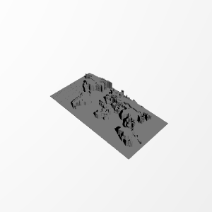
This is a 3d printed world map based on ranks of countries by the Good Country Index 1.2 (2007).
You can find more information on wikipedia:
https://en.wikipedia.org/wiki/Good_Country_Index
I have changed each color to a specific height. so, the heiger the altitude, the better the country.
It is possible to add color to the printed object too. but it is a work of art and I cannot do it.
This method can be used to show any index, e.g. GDP, population, ... about countries.
Licencia


Detalles de impresión
I divided it into 2 parts because of the limitations of my printer's bed.
I used a 0.4 mm nozzle.
Información técnica
| Date published | 18/08/2019 |
| Sin apoyo | YES |
Más información
Archivos